![]()
![]()
![]()
![]()
![]()
![]()
![]()
![]()
![]()
![]()
![]()
![]()
![]()
![]()
![]()
Background
The SS RICHARD MONTGOMERY was a US Liberty Ship of 7146 gross tons. She was built in 1943 by the St John’s River Shipbuilding Company of Jacksonville, Florida and was one of over 2700 of these mass-produced vessels built to carry vital supplies for the war effort.In August 1944 the ship was loaded with a cargo of some 7000 tons of munitions and joined convoy HX-301 bound for the UK and then on to Cherbourg. On arrival in the Thames Estuary, the vessel was directed to anchor in the Great Nore anchorage off Sheerness. The ship was to await the formation of a convoy to continue the journey across the Channel. However, on the 20th August 1944, she dragged her anchor in the shallow water and grounded on a sandbank running east from the Isle of Grain approximately 250m north of the Medway Approach Channel.
The vessel grounded amidships on the crest of the sandbank and intensive efforts began to unload her in order to lighten the vessel so that she could be refloated and also to save the cargo of munitions that were vital for the Allies post-D-Day advancement. Unfortunately, by the next day, a crack appeared in the hull and the forward end began to flood. The salvage effort continued until the 25th September, by which time approximately half the cargo had been successfully removed. The salvage effort had to be abandoned when the vessel finally flooded completely.
The wreck of the SS RICHARD MONTGOMERY remains on the sandbank where she sank. The wreck lies across the tide close to the Medway Approach Channel and her masts are clearly visible above the water at all states of the tide. There are still approximately 1,400 tons of explosives contained within the forward holds.
Protection
The wreck is designated under section 2 of the Protection of Wrecks Act 1973, which means that there is a no-entry exclusion zone around the wreck. The wreck is clearly marked on the relevant Admiralty Charts. The exclusion zone is defined by the following co-ordinates:51° 28’ 04” N 00° 47’ 12” E
51° 27’ 57” N 00° 47’ 22” E
51° 27’ 50” N 00° 47’ 11” E
51° 27’ 58” N 00° 47’ 01” E
Medway Ports is contracted by the Maritime & Coastguard Agency to mark and guard the wreck. This includes the provision and maintenance of warning notices on the wreck, which are fastened to the masts.
Medway Ports is also contracted to provide and maintain a circle of buoys around the wreck to ensure that shipping avoids the area. In addition, the wreck is under 24-hour radar surveillance by Medway Ports. Medway Ports, whose operations room is within sight of the wreck, provide a first line of response to any incursions within the area.
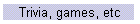
Multibeam sonar images of the wreck acquired by the Archaeological Diving Unit, St Andrews University 2002
Surveys
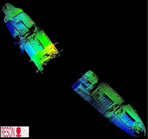
The wreck of the SS RICHARD MONTGOMERY has been subject to regular surveys since its grounding, with a variety of methods being used to monitor the site. Until 1984, surveys were carried out by Ministry of Defence (MoD) salvage divers. More recently, surveys have been undertaken on behalf of the Maritime and Coastguard Agency by contractors working under MoD supervision. Due to the extremely poor visibility on site, after the 1993 survey it was decided that full advantage should be made of advances in sonar technology in preference to the use of divers. A series of sonar surveys were undertaken by Sonar Research and Development, to form a baseline model of the changes to the wreck and the seabed. This survey policy was followed until 2000 and provided some excellent images and information on the condition of the wreck and its environment.Divers were again employed on site during the 2003 survey in order to undertake ultrasonic hull thickness analysis, and to provide an up-to-date assessment of the level of seabed support of the wreck and of the main crack at No 2 hold.
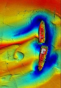
More recently, high-resolution multibeam sonar surveys of the wreck have been undertaken by ADUS St Andrews University.
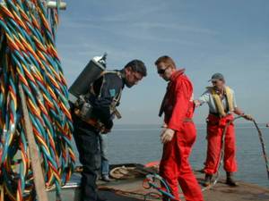
2003 Survey in progressManagement
Whilst the risk of a major explosion is believed to be remote, it is considered prudent to monitor the condition of the wreck. As stated above, surveys are carried out by the Maritime & Coastguard Agency on a regular basis to ensure that any changes to the wreck, or its immediate environment, are discovered quickly. Although it is clear from the results of these surveys that the hull is subject to prevailing environmental conditions and is showing some evidence of deterioration, over the past ten years there has been little change and the wreck is considered to be in a stable condition. Some remedial work to trim the rigging etc from the masts (above the water line) was undertaken in October 1999 with the aim of reducing stress levels on the masts and derricks.Further work
Further work to look into the future management of the wreck of the Richard Montgomery is currently being undertaken.